Category Archives: ABQ

Dangerous by Design

Carmel Rd.
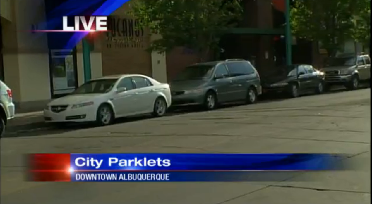
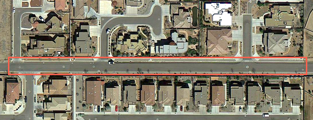
Last Friday, one of the local news stations featured a segment about speeders in vehicles destroying the quality of life in the neighborhood.  The story focused on the stretch of Carmel Ave. pictured above and highlighted by the red rectangle.  A few portions of the segment drew my attention.

1) Emergency Access Creating Emergencies: The neighborhood has requested speed bumps but apparently they can not put in speed bumps because Carmel Ave. is an emergency access route.  The irony here: this provision creates conditions which will inevitably necessitate more 911 calls.  When someone is hit at 40 miles per hour, their chance of survival stands at 5%.  If they are hit at 20 miles per hour, their chance of survival is 85% (source).  How fast do you think people are driving down this street?  Installing speed bumps would increase emergency response time by a few seconds.  Installing speed bumps or some other traffic calming would also increase quality of life and walkability, reduce speeds and create a better neighborhood.  It would appear that our priorities as a city are a bit off.

2) Neighborhood Streets as Highways: Looking at this street, both from the news segment video and from Google Maps, it’s too wide for its intended use.  There is enough space on this street for on-street parking and two way traffic.  On street parking is a great way to slow down driving speeds in neighborhoods.  However, there aren’t any houses fronting this streets.  This means that there are rarely vehicles parked on this street.  Therefore, the street feels to drivers like a desolate rural highway and the drivers treat it as such.

SOLUTION

It seems that the neighborhood is in a pickle.  What can they do?

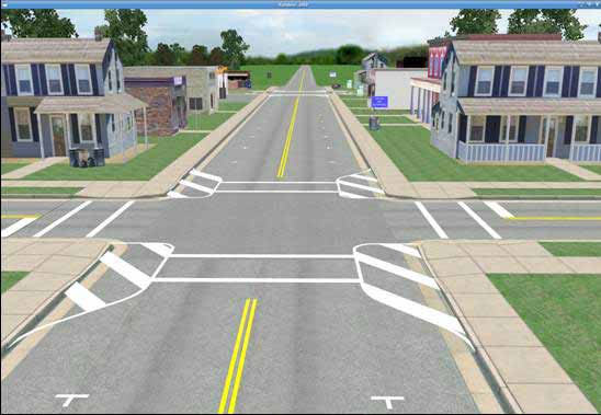
The short term answer: paint.  Though it’s not as good as building actual curb extension,  painting bulb-outs, displayed in the image below, can help to visually narrow the street, reducing speeds.  It also won’t impede emergency vehicle access.  Eventually, the neighborhood should campaign for physical infrastructure improvements.  Until then, paint could really help.

painted bulb outs

-Dan

Parklets Hit the Primetime

this one!
Channel Four News aired a segment last night about parklets. Tim Trujillo gracefully covered the subject in the video segment, explaining the social and economic benefits of having safe and pleasant places to hang out and spend time Downtown. Here’s a link to the full article and video.

In cities where parklets have already been built (such as NYC and San Francisco) local businesses were not initially supportive. Once businesses realized people spent more money in places where they could safely sit, demand for parklets and plazas increased. For example, in Times Square NYC, a large portion of Broadway Blvd. was converted into a plaza in 2009. Since that change occurred, retail sales and rent values have skyrocketed (Streetsblog NYC). All over America and the world, residents and planners are realizing that people are the key to successful places and spaces; cars are secondary. Soon, Albuquerque will join a group of great American cities that prioritizes space effectively and reallocates space from cars to people without much more than a signed piece of paper. Until that moment, we must all join together and tell our city what we want.

Albuquerque is NOT for cars; it is for us, people, Burqueños. We want to walk and bike and use all of the streets safely. Our city leaders understand this but they need to hear the message more forcefully. Other cities across the country are beginning to realize that endless low density sprawl is a recipe for economic disaster. A strong core is key to the success of a metro area and parklets are a step in the right direction.

-Dan

Multi-Modal Experience, ABQ, 2013

Multi-Modal Experience Poster
On April 19, I experienced the Multi-Modal Experience event Downtown. It included lectures, a walking tour and a biking tour. The event took place in an office building on Old Route 66 in a room with walls covered in interesting and innovative solutions to our current mess of automobile dominant development. It is known as the UNM City Lab.

LECTURES + LOCATION
Julie Luna of MRCOG delivered an impressive lecture summarizing a road safety analysis done by MRCOG and staff on a segment of Central Avenue just west of the river. The analysis led to some unexpected findings such as the real and perceived dangers of jaywalking. It included interesting and useful information about user behavior on that stretch of road, specifically bicycle users (many wrong-way riders) and people on foot.
Members of CABQ mayors staff made presentations about ABQ The Plan, ABQ Ride, Route 66 and the proposed 50 Miles Loop. Sections of the future loop were explored on the biking tour in the afternoon. City staff members emphasized the importance of using public investment to leverage private investment.
Erin Marshall had a great presentation about the connection between the built environment and obesity. She covered Safe Routes to School, MAP-21 transportation policy updates, Complete Streets and more.

SEEN ON THE STREET
One of the neat elements included as a part of this conference were actual temporary urban improvements. A large mobile bike corral, filled with bikes, occupied the front of the building.
BIke corral
During lunch, a parklet/parquito replaced a couple parking spaces. A food truck (the always tasty Boiler Monkey) and a busker completed the vital urban space.
Parklet!

BICYCLE TOUR
After a self-guided walking tour around Downtown, everyone met at a parking lot on 6th & Central. Routes Rentals and Tours brought funky cruiser bicycles for attendees to use. The tour led us through a variety of different areas, from Old Town to the South Valley. Along the way, we discovered the great, the bad and the awful bicycle infrastructure which exists in Albuquerque. Different people talked at different stops along the way. It was helpful to really get out and see the infrastructure we were talking about in the conference. The walking tour and bicycle tour helped to emphasize what is currently working well in the urban landscape and what is not.
Bike tour

CONCLUSIONS
This event was a mix of inspiring and discouraging. The presentations by the City of Albuquerque staff emphasized the reservations I have about ABQ The Plan. When bicycle infrastructure is discussed, the emphasis is always recreation and never bicycles as transportation. When BRT is brought up, flexibility is emphasized more heavily than consistency, reliability and permanence. In other cities across the country, bicycling is being used for business incubation. That conversation needs to be going on. Once can generally find the same set of professionals found at these types of conferences. Where are the local residents? Where are the transit users? The gap between academia and reality is unfortunate and difficult to overcome. However, we at least left the room at this conference. We actually went out and engaged with local urban environment. This is key to change occurring. Overall, it was an informative and useful conference. I expect and hope more urban engagement at the next one.

Did you attend this conference? Do you think ABQ The Plan is on a good path? Comment below with ideas and questions.

Design Your Own Street – Central Ave.

This is an example of a streetscape created with Streetmix
Example of a streetscape created with Streetmix

Our post yesterday set the stage well for this post, which will allow the reader to choose street space priorities on his or her own.

Though this was posted a couple of months ago on Atlantic Cities, this neat application is especially relevant as the Central Ave. complete street plan moves forward.

The Central Ave. redesign process (or any street redesign process) is contentious as there is limited right of way, or ROW. Up until the project breaks ground and even after, people will debate the best and highest use of the limited ROW available, especially between I-25 and University. It may seem obvious to us what the best use of the space is but it’s helpful to see what other citizens think about the matter.

Streetmix allows the planner, citizen and any other interested party to truly feel out the options. It allows one to see how many feet of ROW each mode uses.

Here is the approximate available ROW on Central Ave. where this redesign process will be happening.

Between Broadway and I-25 (EDo) –> 83 ft.
Between I-25 and University –> 96 ft.
Between University and Girard –> 115 ft.

The challenge: how much can you squeeze in? BRT (bus rapid transit) lanes? Bike lanes? On street parking?

Happy planning!

-Dan

BRT & Complete Streets

Image
EmX in Eugene, OR, a prototype for aspiring BRT systems.
 
Albuquerque is setting the course for a BRT network, with Central Avenue as the backbone. Some argue that streetcars and light-rail are better but they often have no supporting evidence. First of all, BRT and streetcars are technologies intended for different contexts – the latter is for local service. However, when LRT and BRT are compared, research points to the two having equivalent effects on development. The keys are really in the land use policies and station area design. 
 
This brings me to the current Central Avenue Complete Street Plan being undertaken currently, spanning the area between Girard and 1st Street. This stretch of Central connects the UNM/CNM area with downtown, making it possibly the most important stretch of road that requires the right balance to be a successful multimodal corridor.
 
Without getting into the details of what exists today, I want to argue that it is imperative that the City choose to prioritize non-auto modes over the automobile when applying a design along this stretch of Central Avenue. The chosen design will either maintain the maximum number of travel lanes (the four that currently exist), to the detriment of pedestrian, bike, or on-street parking. Or it will make a stand (a huge statement in our car-obsessed city) and choose sidewalks, bike lanes, and on-street parking, while eliminating a single lane of travel in each direction in order to accommodate dedicated BRT lanes. 
 
The worst thing the City can do is to not take a stand on the issue and force buses to merge with automobile traffic. However, such a compromise would be about par for the course. Reliable, rapid transit is the key here as it is vital to leveraging such an investment to maximize on social and economic benefits. 
 
If we have learned anything in planning and urban design over the last decade, it can be boiled down to the statement (and I can’t remember who said it first): when we plan for cars, we get cars. When we plan for people, we get people. Our City is obsessed with designing for efficient automobile flow. As a result, we have streets that are downright inhospitable to pedestrians and bicyclists. We also have excessively high rates of pedestrian-vehicle accidents and fatalities. I think it’s time to do things differently. 
 
The scale and quantity of development coming down the pipeline for this corridor demands true and intelligent solutions – not compromise. Compromise will just result in more people being stuck in traffic awaiting the next expensive “fix.”
 
-Tim
 
Image
 
Quick sketches for possible ROW design along Central.